Dogs Unknown

Features
Birding · Fall Colors · Lake · River/Creek · Views · Wildflowers · Wildlife

You must register at the trailhead if you plan on camping.
Need to Know
There are two zones where avalanches have left the trail covered in dead fall and some route finding is required. While not necessarily complicated for humans, note that both zones can be difficult for our four legged friends, as they require traversing some combination of dead fall, talus, or slogging it through marshland.
Approaching from the west, the first avalanche zone has some evidence of hikers attempting to veer left, but this is a red herring, as would quickly be discovered. To cross this zone, you'll need to cut through the right and then follow the faint path of broken branches basically right through the center of the zone. At the end, you'll drop a few feet down some boulders to land right at the continuation of the path on the other side. As this requires climbing over sharp logs and branches, be careful that dog bellies don't get injured.
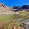
The second zone has talus on the left and a lake on the right, but no straightforward path through. The choice is yours.
Description
The trail starts on a ridge before dropping to Cross Creek. Around mile one, you'll cross the creek on a bridge in a meadow that very often full of vibrant wildflowers. Continue slightly further to pond that's encompassed by rocks. This is a great picnic locale.
Near mile two, you'll be able to see Mount of the Holy Cross from the trail. Although you won't get a good look at it from this perspective, the mountain is named after a permanent cross-shaped snowfield on its eastern face. At mile six, there is an intersection with Grouse Mountain Trail. About 2 miles further, you'll come to Reed's Meadow, a vast meadow in a glacially carved valley.
On the way to Treasure Vault Lake, short side trips to Harvey Lake (at mile 11) and Blodgett Lake (at mile 13) offer good fishing and timberline lake scenery. The last few miles of the trail pass through open meadows with wildflowers and mining relics. There is evidence of mining cabins, ore mills, and old mines. The trail follows an old wagon road to Treasure Vault Lake and the intersection with the Missouri Lakes Trail #2003 and
Fancy Pass Trail #2006.
Flora & Fauna
Wildflowers, elk, moose, and other common alpine plants/animals.
Contacts
Shared By:
Brian Smith
with improvements
by Sebastian Awatramani

 Continue with onX Maps
 Continue with Facebook


 Particularly Special Place


 Intermediate/Difficult

 4.5 (8)


1 Comment