
 Continue with onX Maps
 Continue with Facebook


 Particularly Special Place


 Difficult
Difficult
Difficult
 Difficult
Land Manager: NPS - Great Smoky Mountains National Park
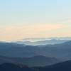
 Fontana Dam - Shuckstack Fire Tower
9.2 mi 14.7 km • 2,371' Up 722.77 m Up • 2,371' Down 722.71 m Down

 Robbins…, NC
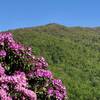
 Gregory Bald Out and Back
9.1 mi 14.6 km • 2,198' Up 669.89 m Up • 2,198' Down 669.88 m Down
Maryville, TN
 Thompson Loop
7.3 mi 11.7 km • 642' Up 195.79 m Up • 641' Down 195.36 m Down
Bryson…, NC
Clingmans Dome
1.3 mi 2.1 km • 327' Up 99.71 m Up • 326' Down 99.42 m Down
Bryson…, NC
Deep Creek to Clingmans Dome
49.5 mi 79.6 km • 9,414' Up 2869.43 m Up • 9,410' Down 2868.3 m Down
Bryson…, NC
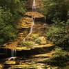
Deep Creek Loop
5.1 mi 8.2 km • 847' Up 258.19 m Up • 854' Down 260.16 m Down


0 Comments