
Land Manager: USFS - Daniel Boone National Forest Office
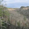
 Auxier - Courthouse Loop
4.8 mi 7.7 km • 669' Up 203.81 m Up • 669' Down 203.91 m Down

 Stanton, KY
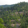
 Hanson's Point Loop
9.7 mi 15.6 km • 1,782' Up 543.2 m Up • 1,782' Down 543.13 m Down
Frenchburg, KY
Pinch-Em Tight Ridge Loop
4.0 mi 6.5 km • 607' Up 185.04 m Up • 608' Down 185.18 m Down
 Chimney Top Trail #235
0.6 mi 1.0 km • 58' Up 17.57 m Up • 58' Down 17.64 m Down
Frenchburg, KY
Sheltowee - Osborne Loop
19.8 mi 31.9 km • 2,474' Up 754.15 m Up • 2,501' Down 762.45 m Down
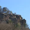
Bald Rock Loop
4.5 mi 7.3 km • 624' Up 190.2 m Up • 625' Down 190.37 m Down

 Continue with onX Maps
 Continue with Facebook


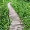
 Particularly Special Place


0 Comments