
 Continue with onX Maps
 Continue with Facebook


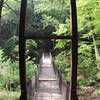
 Particularly Special Place


 Difficult
Difficult
Difficult
 Difficult
Land Manager: PA DCNR - Main Office
 Lake Shore Trail
3.5 mi 5.6 km • 61' Up 18.6 m Up • 62' Down 18.84 m Down

 Bedford, PA
 Everett MST Loop
9.3 mi 15.0 km • 1,134' Up 345.65 m Up • 1,133' Down 345.45 m Down
 Balanced Rock-Laurel Run Loop Hike
4.0 mi 6.4 km • 732' Up 223.13 m Up • 712' Down 216.91 m Down
 Marsh Trail
0.5 mi 0.8 km • 10' Up 3.18 m Up • 10' Down 2.98 m Down
Mid State Trail (MST)
325.1 mi 523.2 km • 45,161' Up 13765 m Up • 44,599' Down 13593.7 m Down
Bedford, PA
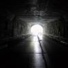
Pennsylvania Turnpike Abandoned Tunnels
17.6 mi 28.4 km • 2,132' Up 649.82 m Up • 2,131' Down 649.65 m Down
McConne…, PA


0 Comments