
 Continue with onX Maps
 Continue with Facebook


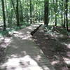
 Particularly Special Place


 Intermediate
Intermediate
Intermediate
 Intermediate
Land Manager: Land Trust of North AL
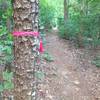
 Jean Shorts Special
4.6 mi 7.5 km • 755' Up 230.21 m Up • 754' Down 229.93 m Down

 Owens C…, AL
 Hays Preserve Loop
1.9 mi 3.0 km • 20' Up 6.09 m Up • 20' Down 6.17 m Down
 Green Mountain Preserve and Buzzard Falls
4.6 mi 7.5 km • 313' Up 95.45 m Up • 313' Down 95.55 m Down
Owens C…, AL
Madkin Mountain Loop
3.8 mi 6.1 km • 222' Up 67.77 m Up • 222' Down 67.76 m Down
 Wheeler Wildlife Refuge: Buckeye/Goose Pond
12.0 mi 19.3 km • 144' Up 43.96 m Up • 144' Down 43.76 m Down
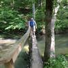
 Walls of Jericho
6.7 mi 10.7 km • 1,371' Up 417.73 m Up • 1,370' Down 417.72 m Down
Hytop, AL


0 Comments