Dogs Leashed

Features
Fall Colors · River/Creek · Views · Wildlife
Overview
I love this trail. I found it on a list of "best trail hikes in the country" and decided to give it a try during my travels. I have visited twice and had an amazing experience both times.
Singletrack the whole way. Isolation, creeks, descents and climbs.
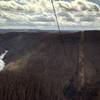
There are a couple of nice vantage points, but the views are not the reason to come to this trail. The "feel" you get from the surrounding woods and from the trail is something that I have infrequently found elsewhere. There is an intimacy with nature on this hike. I have come away from both trips not tired or worn out, but rejuvenated.
Description
From the parking area, you'll walk up the dirt, service road for ~ 1/4 of a mile to get to the trailhead. A sign will point the way up the hill to your left. Do not expect to start hiking right away as you'll face a steep climb to meet up with the trail coming from a secondary parking area.
Once the trails meet, the hike heads to the right and the fun begins. There will be several undulations. I picked my turn around point to be at the creek crossing where there is a wonderful backcountry camping spot. Spend some time there. Enjoy the cool water and the sounds of nature. Soak it in.
You can continue to follow the trail for quite some time if you want a longer hike (I believe the whole length of the trail is 70+ miles) or turn around here for close to 12 miles total.
Flora & Fauna
Hardwood forest. There are amazing colors in autumn. Deer and other typical woodland critters.
Contacts
Shared By:
Jason Doedderlein

 Continue with onX Maps
 Continue with Facebook


 Particularly Special Place


 Difficult

 4.5 (15)


1 Comment