Dogs Leashed

Features
River/Creek
Family Friendly
The picnic area and viewing/fishing dock are a short distance from the main parking lot.
Overview
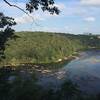
This route offers a nice romp along the river with picnic areas, a viewing/fishing dock, and some interesting rock formations on the north side. As you hike southwest, the trail follows the river, wanders through the forest over some mild elevation ridges and foot bridges, then comes back up along the river as you head northeast again.
Need to Know
Bring $5.00 for the parking pay station or get an annual pass for $40 at Island Ford Visitor Center if you plan on visiting the Chattahoochee trail systems often.
Wear long pants on this trail, even in the summer if you want to make sure you are protected from poison ivy! Much of the trail is narrow and it can get a bit tight and overgrown in spots. You'll also be ducking a few young tree branches and possibly some spiderwebs.
The spiderweb of intersections in the southwest section of the trail system can get a bit confusing. The featured hike route avoids most of the confusion. If you read the description carefully and look closely at the signpost maps along the way, you should be fine. You can also use the
Hiking Project mobile app to help find your way.
Description
From the parking lot, start at the trailhead next to the bathrooms and parking pay station. This will be JB 3 on the map. Take this short connector trail (only a couple hundred feet or so) to meet up with the main trail at JB 4. The map signpost here is blank, but it will dead-end onto the trail paralleling the river. Take a right here. For the next half mile, the trail continues to follow along the river through the forest, and crosses through the parking area for the boat ramp (which you'll have seen while driving in along the access road to the trailhead parking lot). Before the boat ramp area, the trail is mostly singletrack. Although the trail itself is clear (if not wide), you'll be in close quarters with the bushes and young trees growing over the trail and may have to duck and dodge a bit. Once you pick up the trail on the other side of the boat ramp (JB 6), it does open up a bit for the next half mile with slightly wider trail and more open woods (although you'll still remain under canopy cover for almost the entire outing).
At about 1 mile in, the trail turns to the right towards a set of wooden stairs sunken into the trail that starts you up a switchback onto a small elevation ridge. It soon levels out and comes back down to cross a narrow gravel service road before plunging back into the woods with another (much more gradual) elevation gain. As the trail levels out again, you'll go over a very small wooden “bridge” (no sides or rails, just a flat wooden structure). Here, the trail appears to split with an option to go to the right, but stay straight (the right path dead-ends towards a parking lot and building). Continue across a brief clearing with power lines and back into the woods. The trail here is mostly level with very gently rolling elevation.
Just under 1.5 miles from your start, you'll arrive at JB 7, which begins a spider web of trails with multiple intersections and loops. The JB 7 signpost map will be on your Left as you pass it, and will be facing away from you as you approach (as most of the signs will be). Keep right from the direction you came and find JB 22 almost immediately, staying right here as well. The trail climbs gently and steadily to JB 20, where you'll see a small parking lot and building as you turn hard left at the signpost. After about a quarter mile of gradually descending/flat trail, come to signpost JB 21. Here, you'll take a left (if you go straight, it will dead-end onto private property).
The trail gets a little more overgrown, or at least tight here, but is passable. You'll soon come to another apparent fork in the trail (there is currently a pine tree in the middle of the fork) and stay left again (to avoid the same dead-end on private property). Arrive at JB 10, take a right, and cross a small footbridge.
JB 11 will appear shortly after and stay straight here (not left). This is another tight section where you might have to duck under some young trees, but it is short.
JB 13 is a 4-way intersection. Take a left to head towards JB 14. Stay straight at JB 14 (not right across the bridge) and the trail will loop to your left to follow along the river again. This section is more spacious and scenic: the forest floor has a carpet of tender green ground foliage and ferns and the river is visible to the right. At this point, you are about 2.5 miles in.
The trail curves left away from the river briefly to arrive at JB 12. Make a right here to head back towards the river.
Follow this section (also along the river) until it curves away again at JB 8. Stay straight here for a very brief climb to arrive at JB 7. Make a right here to head back the way you came in, along the gentle elevation ridges through the forest, back along the river and across the parking lot for the boat ramp, and eventually arriving back at the blank sign that is JB 4 (where you'll be able to see the bathroom area at the parking lot to your left through the trees.)
You can duck out here to head back to your vehicle.
Flora & Fauna
Large population of waterfowl wade and fish in the shoals here (geese, cormorant, ducks, blue heron).
Contacts
Shared By:
Heather Pruner
with improvements
by Asa Wilson

 Continue with onX Maps
 Continue with Facebook


 Particularly Special Place


 Intermediate

 Medlock Loop

 Gold Branch Loop
 Roswell, GA


0 Comments