Enjoy superb views of DeLacy Meadows, Shoshone Lake, Shoshone Geyser Basin, Lone Star Geyser, and the Firehole River on this great route. Note that your starting and ending points aren't the same, and plan accordingly!
This route begins on
DeLacy Creek Trail at a trailhead located on the
Old Faithful to West Thumb road where it crosses DeLacy Creek. From the trailhead, the trail follows DeLacy Creek for three miles dropping 150 feet to its inlet to Shoshone Lake. After a mile, the trail breaks out of the forest and enters beautiful DeLacy Meadows.
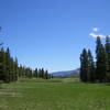
For several miles, the trail skirts the eastern side of the meadows affording nice views. The meadow grows wider as it approaches the lake. At the 3-mile mark, the trail reaches the lake and a junction with the
North Shore Shoshone Lake Trail which branches to the right. Shoshone Lake, at 8,050 acres, is the second largest lake in the park and is the largest backcountry lake in the lower 48. It's got brook, lake, and brown trout too!
At this junction, take a right onto the
North Shore Shoshone Lake Trail. The trail follows a beautiful beach across the north end of Shoshone Lake. You'll have little trouble negotiating the crossing of DeLacy Creek. These are some of the finest views visitors can get of the lake, which is best experienced by canoe. At the 5.5-mile mark, the trail swings away from the shore and enters the trees. From there, the trail travels 5.8 miles through fairly uninteresting lodgepole forests to a junction with the
Shoshone Lake Trail.
As you continue along the North Shore Trail, at the 8-mile mark you'll pass three short spur trails. The first two lead to backcountry campsites (8R2 & 8R3) and the third leads to the Cove Patrol Cabin. Each spur affords nice views of the lake. The trail then reenters the lodgepole forest and continues another 3 miles to a junction with the
Shoshone Lake Trail at the 11.3-mile mark.
From the junction, turn left and follow the
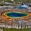
Shoshone Lake Trail less than 1/2 mile to tour Shoshone Geyser Basin, which is the highlight of the journey. Be sure to allow enough time at the basin, at least one hour is necessary to explore the many geysers and hot springs on either side of Shoshone Creek. The largest geyserite deposit in the basin belongs to Minuteman Geyser, which you'll see first. During its active phase, its eruptions almost live up to the name. Union Geyser, with three conspicuous cones, lies on the same side of the creek at the south end of the basin. On the opposite side of the creek, Lion Geyser and Bronze Geyser occasionally erupt.
Once done exploring the area, head back the way you came on the
Shoshone Lake Trail, take a left at the junction, and continue on the
Shoshone Lake Trail as it follows Shoshone Creek into a nice-sized meadow and gradually climbs from the geyser basin. Along the way it passes junctions with the
Bechler River Trail and the
Shoshone Geyser Basin Horse Cutofff Trail (both on left).
About 3 miles from the geyser basin, after a gradual 200-foot climb you'll reach unmarked Grant's Pass on the Continental Divide. The pass was named for President Grant, who signed the bill creating Yellowstone on March 1, 1872. From there, it is a steady 350-foot descent over the next mile through a forest, before entering a lovely meadow and heading onto a bridged crossing of the Firehole River, at the 18-mile mark. Shortly after this crossing, you come to a junction where you'll take a right on the
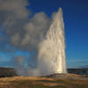
Lone Star Geyser Trail and you'll soon come across its namesake - Lone Star Geyser, which erupts about every 3 hours. Lone Star's 10-foot geyser cone is one of the largest in Yellowstone, indicating that this geyser has been erupting here for hundreds, perhaps thousands of years. And its 45-foot eruptions which shoot from the top of the cone are well worth the wait!
Passing the geyser, the now-paved trail heads through a small meadow with nice views of the Firehole River. The trail continues along the Firehole through a forest partially burned by the 1988 fires. The route ends at the
Lone Star Geyser Trail located just south of
Kepler Cascades on the
Old Faithful to West Thumb Road.
Thanks to guidebook author, Tom Carter, for sharing this trail description. To learn more about visiting Yellowstone, check out his book,
Day Hiking Yellowstone.
I often see (and hear) sandhill crane in DeLacy Meadows. These light-brown birds stand as tall as a deer and have a maximum wingspan of 6 feet. Long-legged and long-necked, they look similar to the great blue heron, but can be distinguished by a red patch on the head. Listen for their shrill, musical, ratchet-like call.

 Continue with onX Maps
 Continue with Facebook


 Particularly Special Place


 Intermediate

 Observation Point-Geyser Hill

 Mystic Falls Loop
 Yellows…, WY
 Moose Basin


1 Comment