From the Warm Creek Trailhead the trail climbs steeply over the 950-foot north shoulder of Barronette Peak (10,404') in the first 1.2 miles. Near the top, views of Abiathar Peak (10,928') and Amphitheater Mountain (10,847') back across the valley become good. The trail then drops 270 feet, briefly following a 1988 fire line cut in defense of Cooke City, MT, and at 1.9 miles reaches the banks of
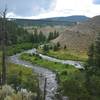
Pebble Creek. Here the rare beauty of upper
Pebble Creek unfolds. Lush green meadows abound that are guarded by high mountain peaks. The most striking of these mountains is ominous Cutoff Mountain (10,695'), whose sheer rock face towers above the valley to the northwest.
The trail crosses Pebble Creek, bends left and continues downstream closely following it. The next 3 miles through open meadows along
Pebble Creek are a highlight of the trip. There’s a chance to see elk in the valley and bighorn sheep and mountain goats in the craggy mountain tops. Along the way the trail fords the creek a second time at 3.5 miles. The impact of the 1988 fires is quite evident throughout this upper part of the valley.
At 5.5 miles, turn right and follow the
Bliss Pass Trail. It immediately fords
Pebble Creek and quickly sets to steeply climbing 1600 feet to the pass. At this lower elevation trees are a mixed forest of spruce, fir, and lodgepole pine. As you climb higher the views to the south (of Mount Hornaday) and east (of upper
Pebble Creek) become increasingly good. Near the pass, five-needled limber pine is added to the forest mix.
At 7.5 miles the trail abruptly levels out and the trees become sparse as you reach the eastern side of the pass. Be sure to scramble up the small hill to the right for the best views of upper
Pebble Creek which forms a magnificent amphitheater. The snow-clad Beartooth Mountains are also visible to the northeast beyond the park boundary. I thought "Bliss" was an appropriate name for such a beautiful pass until I discovered it was named for a local rancher named Bliss.
The trail continues over fairly level terrain and then begins its long, 2700 foot descent to the beautiful meadows of
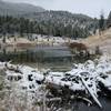
Slough Creek. At the 12.6-mile mark the trail intersects with the
Slough Creek Trail near the Elk Tongue Patrol Cabin. The patrol cabin area is a nice place to have a picnic or cast a line. Or just rest a bit and enjoy the views of the “Third Meadow” and imposing Cutoff Mountain from this side of the pass.
Slough Creek was named in 1867 by gold prospectors who said it "Twas but a slough," and the name stuck. This beautiful stream is the holy grail for many fly fishermen, in fact some guidebooks proclaim it to be the finest cutthroat trout stream in America, if not the world! Bring gear and try your hand (catch and release only), but also bring a Yellowstone Fishing Permit.
Once you’ve enjoyed the area, continue the journey southwest on the
Slough Creek Trail. It’s actually an old wagon road to the Silver Tip Ranch, a century-old guest ranch that caters to hunters and fly fishermen. The ranch lies just beyond Yellowstone's northern boundary. Occasionally wagons are seen along the road taking guests or supplies to the ranch.
The trail continues southwest along the wagon road and skirts this beautiful wide valley for the next 5.5 miles. Nearby
Slough Creek rolls tirelessly along on it's meandering path. Soon you’ll enter
Slough Creek’s “Second Meadow.” At the 14-mile mark notice how the creek has over time changed its course and left scars on the land, even a small oxbow lake. At 15.5 miles the trail begins brief rise away from the creek and then rejoins it at 17.3 miles, as it enters the “First Meadow.”
At 18 miles the trail passes another patrol cabin then begins a 170-foot climb away from the creek. The final mile of the trail drops 400 feet and provides occasional views to the southwest of Little America Meadows, through which lower
Slough Creek flows to join the Lamar River. The trail ends just south of
Slough Creek Campground.
Thanks to guidebook author, Tom Carter, for sharing this trail description. To learn more about visiting Yellowstone, check out his book,
Day Hiking Yellowstone.
Small bands of bighorn sheep are often seen along the rocky slopes above upper
Pebble Creek. This small corner of Yellowstone is also the best area of the park to view mountain goats. Though not native to the Greater Yellowstone Ecosystem, these fascinating animals were introduced into the Beartooth Mountains in the 1940s and have crossed over into the park.
Pebble Creek is also a place to see black bear. Elk are often seen along
Pebble Creek and in the high meadows west of Bliss Pass.
Slough Creek is grizzly country. Take precautions. In 1922, a grizzly killed poacher Frenchy Duret on
Slough Creek just north of the park. The entire trail is a delight to the true flower buff.

 Continue with onX Maps
 Continue with Facebook


 Particularly Special Place


 Difficult

 Specimen Ridge

 Hellroaring Creek
 Tower J…, WY


0 Comments