Dogs Leashed

Features
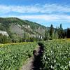
Birding · Fall Colors · Lake · Views · Wildflowers · Wildlife

The gate for the road that goes up to Tony Grove Lake usually closes with the first snows of the winter, and this trail would be very difficult to travel during the winter anyways because the snows get very deep up here.
Overview
This rocky trail goes through some of the most beautiful terrain in the Bear River Range. From the trail, you can get views of Mount Gog and Mount Magog, two majestic peaks, and from the top of Mount Naomi the trail offers great views of Cherry Peak to the northwest, a large portion of Cache Valley to the west, and a large portion of the Bear River Range to the south. The trail can be challenging at times but it's short and well worth the work to get the views from the top.
Description
From Tony Grove Lake, the trail heads out in the direction of Mount Magog, and towards an increasingly barren set of karst and glacially influenced terrain. The trail can be rocky and somewhat steep in places, but it is a gorgeous trail with lots of beautiful views to offer.
The trail never really enters any significant forests, but there are wildflowers in season and fields of sagebrush and grasses along the trail. The trail ascends through this terrain until just under Mount Naomi, then skirts around underneath it and then comes around to it from the north side.
The last push to the top involves some scrambling, but it is fairly mellow, and easy for anyone to do. From the top, you get amazing views of Smithfield Canyon and Cache Valley, as well as Cherry Peak, Mount Gog, and many of the other peaks in the Bear River Range. You also get the satisfaction of being at the tallest point for almost 100 miles in any direction.
Contacts
Shared By:
Tomsen Reed

 Continue with onX Maps
 Continue with Facebook


 Particularly Special Place


 Intermediate/Difficult

 4.2 (9)


0 Comments