Dogs Leashed

Features
Birding · Fall Colors · River/Creek · Views · Wildlife
Overview
This trail is located about 8.5 miles up Poudre Canyon and is often a local favorite and a great trail to hike for someone to get part of the Fort Collins experience. As this trail is located ~25 min outside of town, you get to experience driving up Poudre Canyon. Some great spots to stop on your way up for a picnic or dipping your feet in the river would be Picnic Rock, just a few miles up Poudre Canyon (on your left as you're driving up), and Gateway Mountain Park (on your right side as you're driving up.) Both locations are great for resting or spending time with the family before or after the hike!
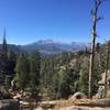
Once at the top of the hike you get a great view of the surrounding area looking down into Fort Collins and up into the canyon. You can also see the Mummy Range in the northern part of RMNP. Generally, the only drawback for most people is the elevation gain; climbing almost 2,000 feet in 3.1 miles is quite the climb in often dry conditions. Planning to do this hike in the morning or a summer evening (bring a headlamp) can be best so you miss the hotter parts of the afternoon.
This isn't the best choice for a first-time hiker – there are many places to take wrong turns. However, there are often lots of folks on a summer weekend!
Need to Know
There have been multiple wildfires in the surrounding area, so often tree coverage can be limited; make sure to dress appropriately and bring enough water and bug spray! Bring flip flops to soak your feet in the river at the end! (This also cuts down on swelling feet.)
This trail is best in the spring and early summer as there is plenty of water flowing in the river (at the start of the trail) and you'll find beautiful ponds at the top of Greyrock.
Description
Starting at the Grey Rock Trailhead, the hike crosses Poudre Canyon Road and a gorgeous bridge before climbing along an open hillside on the
Greyrock Trail #946. After just a few minutes, the trail pops out of the forest at a trail junction with the
Greyrock Meadows Trail #947.
Note that there are two trails for the middle section - the "Meadows" and a more direct
Greyrock Trail #946. #946 gets steeper in sections while still maintaining a relatively clear trail.
I recommend you take the
Greyrock Trail #946 up (take the right at the first junction). Once arriving at the upper junction with Greyrock's summit in front of you, stay to the right to climb it.
Once past the upper junction, there's a short dirt section before climbing a ramp of rock on the southeast side of the actual Greyrock. After leaving the trail, look for the wooden trail posts sporadically placed. There are some easy and solid rocks to scramble as you come up the eastern end. Once into the saddle where folks often camp, look for the rock cairns that will lead you to the top. It's easy to get lost here. If you're scrambling/climbing anything crazy, you're off the direct trail.
After climbing up Greyrock, you'll come back down to this same upper junction, but this time, follow the sign leading you to the
Greyrock Meadows Trail #947 for the way down. This is a nice gradual decline that takes you through a beautiful meadow and allows you to glimpse back at Greyrock for some beautiful views of the entire rock. This is a great meadow to hike through during sunset, with the sun setting in front of you and Greyrock behind you. While you can take this trail up, it will reveal Greyrock about a mile or two before you are actually there. If you take
Greyrock Trail #946 up, you won't be able to see it until you're almost to the upper junction, which allows for more surprise in the beauty.
Flora & Fauna
Like anywhere on the Front Range, make sure to be wary of rattlesnakes! When you're not looking at your feet, keep your eyes peeled for beautiful birds of prey.
Contacts
Shared By:
Steven W

 Continue with onX Maps
 Continue with Facebook


 Particularly Special Place


 Intermediate/Difficult

 4.3 (70)


 All Clear


1 Comment