
 Continue with onX Maps
 Continue with Facebook


 Particularly Special Place


 Intermediate
Intermediate
Intermediate
 Intermediate
Land Manager: USFS - Nantahala National Forest Office
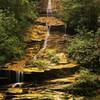
 Juney Whank Falls
0.6 mi 0.9 km • 122' Up 37.16 m Up • 125' Down 38.08 m Down

 Deep Creek to Indian Creek Trail Loop
15.7 mi 25.3 km • 2,136' Up 651.02 m Up • 2,153' Down 656.31 m Down
 Deep Creek Loop
5.1 mi 8.2 km • 847' Up 258.19 m Up • 854' Down 260.16 m Down
 Jakes Creek AT Loop
24.5 mi 39.4 km • 4,600' Up 1402.01 m Up • 4,600' Down 1402.23 m Down
 Gatlinburg, TN
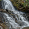
Laurel Falls
Gatlinburg, TN
Laurel Falls
2.5 mi 4.1 km • 351' Up 107 m Up • 351' Down 106.93 m Down
Gatlinburg, TN
Laurel Falls to Cove Mountain Fire Tower
8.4 mi 13.4 km • 1,781' Up 542.99 m Up • 1,781' Down 542.93 m Down


0 Comments