Dogs No Dogs

Features
Views · Wildflowers · Wildlife

Some parts of this loop are closed to dogs.
Overview
This enjoyable loop sees less traffic than the main attraction in this area, the
Mount Sanitas Loop. The other advantages of this loop include a less arduous ascent on a shiny new trail and a quick, efficient descent.
Need to Know
In the spring, the
Sunshine Canyon Trail is one of the last to lose its icy coating, because it's on the north side of a hill. When in doubt, take traction - and if you use the trail please update the trail status here on the website for others.
Description
This loop combines several area trails into a varied, pleasant hike. Starting from the
Centennial Trail at the mouth of Sunshine Canyon near the toilets, head south very briefly, up the road-width trail, to find the start of the
Red Rocks Trail. Almost immediately, you'll leave the
Red Rocks Trail and follow the
Sunshine Canyon Trail as it branches off to the west and crosses a small ravine. Follow the nicely bench-cut trail, contouring
Sunshine Canyon Trail as it parallels Sunshine Canyon Road. This section of low angle trail is not steep and has a mostly smooth surface, passing through fields and fir forest.
The
Sunshine Canyon Trail ends at a residential driveway, adjacent to Sunshine Canyon Road. To access the next part of the loop, follow the signage and carefully cross the road (there's a crosswalk). Turn left and head briefly up the road until you reach the first dirt residential road on the right (east) side of the road. From the intersection you can see stairs indicating the start of the
Lion's Lair Trail.
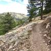
The Lion's Lair trail starts up a small ridgeline sparsely treed with fir. After about 1/2 mile you'll pass the Lion's Lair Spur trail, which would take you to Sunshine Canyon and a few parking spaces. Continue on Lion's Lair.
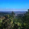
Switchback and contour up the western flank of Mount Sanitas, climbing gently past dry rocky outcrops. There are views of the Continental Divide, and down into Sunshine Canyon. The grade is never steep, and the surface is smooth. As you ascend, you enter a pine forest, and the views get better and better. Be sure to turn around and enjoy the high peaks in the distance. At the end of the trail, you merge onto the main Mount Sanitas trail for the last few feet of rocky stair-like climbing to the summit. At the summit, all of Boulder is laid out in front of you.
Take a breather before descending the
Mount Sanitas Trail. This is a steep, challenging descent down the spine and western edge of Mount Sanitas. Pass over rocky sections and numerous large step-downs. Expect a lot of hiker, runner, and dog traffic on this section of trail. There are several rest spots where you can pull off to enjoy views of town and also the snowy peaks to the west. There are a few rutted steep sections with difficult footing. Towards the bottom, you'll pass some short bouldering cliffs popular with rock climbers. After one last series of tall wooden log steps, you'll cross an irrigation ditch and emerge into a small meadow. Keep to your right, crossing a stream and passing through a covered picnic pavilion. Signs will guide you. Carefully cross Sunshine Canyon Road and head uphill to arrive back at the
Centennial Trail parking area.
Flora & Fauna
A suprisingly wonderful variety of wildflowers in the sunny spots- especially in the early spring months (April & May).
Contacts
Shared By:
Megan W
with improvements
by Emily Goodin

 Continue with onX Maps
 Continue with Facebook


 Particularly Special Place


 Intermediate

 4.5 (144)


0 Comments