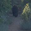
There is good access to water throughout much of the hike, for the benefit of you and any furry friend you might bring along.
This all begins and ends at the Section 16 trailhead, to be found on
Gold Camp Rd.
The Section 16/
Palmer Trail begins with a gentle incline that winds its way up through red rock and scrub oak, affording some great views of Garden of the Gods and Red Rock open space.
There are a couple of unmarked trails that lead off to the right heading to Red Rock Open Space. Stay on the trail that leads uphill and generally looks more used.
After about 1 mile, the trail intersects with the
Intemann Trail, which connects to Red Rock Canyon and heads into Manitou Springs, where it can be used to get to
The Manitou Incline and
Barr Trail. For this route you'll continue straight and shortly after the Intemann connector, the trail climbs into the trees. In the summer, this is a relief. In the winter, expect to start hitting snow and ice.
The incline really picks up at this point. The trail is well marked in the forest and wherever there might be confusion, there is a marker pointing in the right direction. They will be marked, Section 16/
Palmer Trail (Ring the Peak Trail).
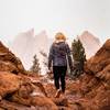
Just over 1.5 miles from the TH, the ridge is reached opening spectacular views to the South. I am always startled when standing at this point, where I see nothing but mountains and trees, that I am standing on city property.
The trail continues to the right (west) where it flattens out. There is some up and down but it tends to be fairly mild. Eventually, the trail begins a sustained drop that is less steep than the climb and a blast to allow gravity to do its work.
After about three miles, the trail reaches the valley and you continue around to the left towards
High Drive, which can be seen when higher up on the trail.
At
High Drive turn uphill (to the left). After about .5 miles Trail 666/Bear
Creek Trail will head off to the right following Bear Creek upstream, while
High Drive heads away from the creek to the left. Take Trail 666.
The trail begins fairly gently but becomes steeper as it climbs above the creek in anticipation of the upcoming cliffs where Bear Creek generates a high cascading waterfall.
After the waterfall the trail continues to climb, but at a gentler grade and it follows the creek more closely.
Eventually, the trail reaches a junction where an unmarked trail (despite a bunch of signs, none of them identify the trails) heads to the left over a bridge. This is where Trail 666/Bear
Creek Trail ends. The trail to the left is Trail 667/Jones Park Trail and will take you back to
High Drive, yet at a much higher point than trail 666. Taking trail 667 back to
High Drive will cut out a few miles from this route.
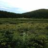
To continue with this hike, continue straight on what is now Trail 667/Jones Park Trail and follow to, you might have guessed it, Jones Park.
Jones Park is a flat meadowy area with Aspen and a creek and several trail connections. One of these connections, Trail 668/Pipeline Trail (Ring the Peak Trail) will cross a small bridge and head south. Continue to follow this trail until you approach a creek (N. Cheyenne Creek). Above this creek, the trail will split with no good signage. Follow the creek downstream. It is here that more joyous and splendid downhill hiking begins.
Follow the creek on what is now the aptly named Seven Bridges Trail (662). This will after a few miles, take you to Gold Camp rd, where you'll take a left to get to the main parking area to access these trails.
Across the parking area there will be two roads. One heading down (Gold Camp Rd) and one heading up (High Dr). Take
High Drive.
After about 1 mile of climbing, a long descent will take you back to where you started it all.
Once you hit pavement, just follow the road to the left (Gold Camp Rd) and the parking area will be 1000 ft up on the right.

 Continue with onX Maps
 Continue with Facebook


 Particularly Special Place


 Intermediate/Difficult

 Section 16/Palmer Loop

 Manitou…, CO
 Mount Rosa via Pipeline Trail
 Garden of the Gods Inner Loop
 Almagre Mountain South via FSR 379


1 Comment